
THE IRONIC EIGHTY MINUTES
During the Woolsey Fire, Santa Monica Mountain evacuees were gridlocked for 80 minutes on the same stretch of Kanan Road the city is currently developing.
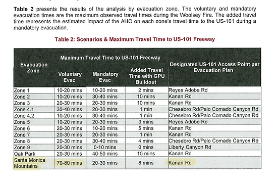
The table below is from page 5 of the Agoura Hills 2022 Evacuation Capacity Report. The City's testing determined that Santa Monica Mountain evacuees traveling north on Kanan Road during the Woolsey Fire took up to 80 minutes to reach the 101 Freeway on-ramps - 30 MINUTES LONGER than any other evacuating group. The same report included the diagram, lower right, on page 25. It shows portion of the route. Compared with Seminole Hot Springs, approximately three miles away, it appears evacuees were timed only during roughly the final mile of their evacuation on Kanan Road. Thus, eighty minutes to travel about a mile, not counting the miles of vehicles behind them.


IRONICALLY, DESPITE THIS AWARENESS
In 2021, the City of Agoura Hills placed three of it's highest density housing sites, A, B AND G, along the same section of Kanan Road where Santa Monica Mountain evacuees sat in gridlock for eighty minutes during Woolsey Fire evacuation.
Two of those projects, Site G - The Regency Project and Site B - Agoura Village West, were the first of twenty on the City's list of housing sites to be ultimately approved by the city for completion.
The largest site on the list is Site A at 12 acres. It is located directly across from Site B on the southeast corner of Kanan and Agoura Roads.

California Wildfires
What have we learned from the WOOLSEY FIRE???
California has been the state most threatened by wildfires, with over 40% of all burned acres in America in 2024 (BEFORE the Eaton and Palisades Fires) occuring within its borders. The state leads in wildfire-prone properties, with 2.1 million homes at risk, a number nearly three times higher than Texas (750,000), Colorado (380,000), and Arizona (250,000), according to the Insurance Information Institute.
SEE ATTORNEY GENERAL ROB BONTA'S GUIDELINES FOR BUILDING IN WILDFIRE AREAS click here
NEW HIGH DENSITY PROJECTS IN CENTER
OF WOOLSEY FIRE MAP
The City of Agoura Hills is building affordable housing, as well it should. California needs housing. The state currently requires that every city and jurisdiction in California build an assigned number of affordable units by 2029. The state does not, however, dictate where the housing will be placed. Those decisions are left to the cities that are building the housing.
The state is requiring the City of Agoura Hills to build 318 affordable units and the city has made plans to comply. In fact, the city plans to build considerably more than 318 units. PRISMM has no problem whatsoever with the housing itself, but the placement of the housing and its inevitable impact upon Kanan Road evacuation is a concern.
The Woolsey Fire of 2018 decimated the Santa Monica Mountains and parts of Malibu.
Notice the turquoise area IN THE CENTER OF THE WOOLSEY FIRE MAP. This is where the City of Agoura Hills has chosen to place 15 of 20 (75%) of the city's housing sites, at the base of the fragile Santa Monica Mountains in the Very High Fire Hazard Severity Zone and Wildland-urban interface - the most dangerous place to build new construction.
Within three miles of these proposed sites, three people died in the Woolsey Fire, hundreds of homes were destroyed and livestock, domestic pets and wildlife perished. The City of Agoura Hills is not only creating a NEW FIRE HAZARD with the PLACEMENT of this housing - much of it high-density, the City is also misrepresenting the danger by submitting a misleading Evacuation Analysis that leaves out a critical portion of Kanan Road and the populations of residents of the Santa Monica Mountains and Malibu.


-
Twenty Housing sites. Fifteen (75%) south of the 101 Fwy.
-
Five largest* sites (25%) are on Kanan Road, the main evacuation route.
-
Seven (33%) on or next to Kanan Road, the main evacuation route.
-
Highest Density sites are on or adjacent to Kanan Road, the main evacuation route.
The City of Agoura Hills has approved projects on 4 housing sites - all in the vicinity of Kanan Road south of the 101 Freeway, with no approved Evacuation Analysis in place.

-
The City of Agoura Hills has rezoned six development sites along Kanan Road to allow construction of high density housing, to add over 1676 units.
-
·Evacuation for Oak Park, Agoura Hills, unincorporated
L.A. County, and Malibu is severely impacted.
-
·The City is placing low-income renters in harm’s way by situating them on an evacuation route that will clog and bottleneck in an emergency.
-
·Two of the most significant apartment complexes are planned at Kanan and Agoura roads, the choke point for evacuation.
-
·The City's Evacuation Plan and Analysis are inadequate and intentionally omit Kanan Road south of the intersection of Kanan and Agoura roads in order to ignore the impact these projects will have on evacuation traffic from unincorporated Los Angeles County and Malibu.

The problem is not added housing. The problem is placing the majority of the city's high density housing along its main evacuation route and approving projects with no Evacuation Analysis in place.
Below is a map of the housing sites south of the 101 Freeway and their "highest unit potential" before the addition of Density Bonuses.
Notice proximity to Kanan Road and freeway onramps, marked in orange marked "1" and "2".

For more details about Agoura Hills' State Mandated Affordable Housing site choices, click here.